




Correcting the Map, as We Must, and Yet Still
“A fair world begins with a fair map”. This is how Togo’s Foreign Minister Robert Dussey introduced the African-led “Correct the Map” Resolution (A/RES/80/297) to the General Assembly. The Resolution seeks to change the Mercator map – the world’s most widely used map – and encourages governments, schools, international organisations and technology companies to use more equal-area representations of the world instead, such as Equal Earth. On 4 September 2026, 164 UN Member States adopted the resolution, only one voted against (guess who!).
The resolution matters because inherited representations organise how the world becomes visible to us – a planetary “us”, the offspring of the Eurocentric modern project. Correcting the map is therefore a matter of justice: recognising and contesting inherited ways of seeing, while cultivating other ways of seeing and inhabiting a world in which those inheritances, like empire itself, refuse to disappear.
Correcting the World
Led by Togo on behalf of the African Group, the initiative builds on a wider African Union campaign against the persistence of a projection that systematically exaggerates the size of territories towards the poles. The effects are familiar. Europe and North America acquire a visual prominence bearing little relationship to their actual territorial dimensions. Greenland, for example, appears comparable in size to Africa – although Africa is around fourteen times larger. South America appears smaller than Europe, although it is almost twice its size.
There are technical reasons – or rather a colonial reason – for this. Flemish cosmographer and cartographer Gerardus Mercator (1512-1594) developed his projection in 1569 for navigation. It preserves angles and allows constant compass bearings to appear as straight lines. The distortion of area is partly the consequence of doing something else particularly well: making navigation easier.
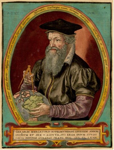
Fig. 1. Gerardus Mercator, by Frans Hogenberg (1574).
Mercator helped, in this manner, to midwife a particular global socio-economic and political order. Europe sits towards its visual centre, at the map’s belly button, surrounded by the routes, encounters, mis-encounters, asymmetries and upheavals through which the modern world was made. Cartography and empire travelled together.
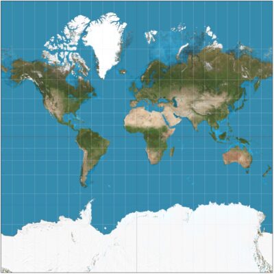
Fig. 2. Mercator projection between 85°3’4″S and 85°3’4″N. Courtesy: Daniel R. Strebe (2011). CC BY–SA 3.0.
There is no perfectly neutral map waiting to be discovered behind Mercator, though. To map a spherical earth is necessarily to choose what will be preserved and what will be distorted. Every projection involves decisions about how the world is to become visible.
Cartographers have long agreed that no flat projection can preserve area, shape, distance and direction at the same time. Each projection depends on what it is intended to show.
Where the relative size of territories matters, however, “equal-area projections” offer the clearest answer: they preserve proportional area while accepting distortions elsewhere. The Equal Earth map – an equal-area pseudocylindrical projection jointly developed by Bojan Šavrič (Esri), Tom Patterson (US National Park Service), and Bernhard Jenny (Monash University) in 2018, does precisely this.
So every projection involves decisions about how the world is to become visible. But some representations are fairer than others. This makes the politics of the “Correct the Map” resolution both relevant and interesting.
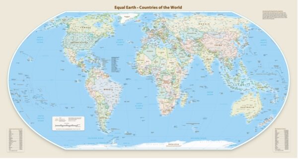
Fig. 3. The Equal Earth Map. Available on equal-earth.com.
As Togo’s Foreign Minister Robert Dussey told the General Assembly, the issue concerns spatial representation, but above all “cognitive justice”: access to geographical knowledge, dignity and historical memory.
Maps become part of our mental geography: they teach us where places are, how large they are, what lies at the centre and what appears at the edges. For children repeatedly encountering Africa or South America diminished beside an enlarged Europe or North America, those proportions become part of how the world is intuitively imagined, and what is more or less important, more or less central to global affairs. Cognitive justice reaches into the infrastructures through which we learn to picture the world.
Belly Button, Mine
The 164–to–one vote on the “Correct the Map” resolution offers its own striking picture of the politics of representation.
The United States, asserting its position as today’s guardian of the belly button of the world described above, cast the only vote against the resolution. US representatives dismissed the initiative as an “ideological project”. For the US, what had been presented as an “anodyne effort to update cartographic proportions” was bound up with a wider agenda of reparations. Questions of “cognitive justice” and cartographic representation became, in this account, a distraction from the “genuine problems” with which the United Nations should concern itself.
There is a wonderful irony here, though. The US response denounces ideology in the attempt to challenge an inherited representation, while treating the inherited representation as a simple map – one that, by the way, makes the United States look bigger and more central.
Mercator’s own politics then become harder to see precisely because its representation of the world has become so familiar, and so fitting for a particular kind of international order. A map – a “re” + “presentation” of the world – that has hung on classroom walls, appeared in atlases and migrated onto digital screens has gradually ceased to look like one map among many possible maps. It has become the world. And to question it is then to question the world itself – and that, apparently, is ideological.
Ways of Seeing
Martin Jay’s idea of “scopic regimes” is helpful here. A scopic regime names a historically constituted way of seeing: a set of visual conventions and practices through which the world becomes apprehensible. For Jay, modernity contains several such regimes, which coexist and compete with each other. Cartesian perspectivalism, however, came to occupy a hegemonic position within Western modernity.
The “Correct the Map” resolution can be understood within this contested field. Mercator is one historically situated way of picturing global space whose institutional repetition and usefulness within a particular modern project have given it extraordinary authority. Its organisation of scale, centre and periphery has become part of our visual common sense. The present dispute concerns that inherited authority.
I have been thinking about this problem recently in terms of the socio-technical cognitive infrastructures of international law. Maps sit alongside graphs, indicators, categories and institutional images as devices through which international institutions make a world legible. They establish relations of proximity and distance, centre and periphery, importance and marginality. In other words, how international law sees becomes part of how international law governs.
Timothy Mitchell takes this question into the terrain of colonial power and political economy, an approach I have found very helpful in the past. Drawing on Heidegger’s ideas of the world as picture and enframing, Mitchell describes the emergence of a “world-as-exhibition”: a world increasingly laid out before an observer, organised into objects that could be seen, classified and known. He traces this way of seeing and ordering across colonial exhibitions and travel, and into the late colonial and later postcolonial reorganisation of cities, agriculture, education, communication and other techniques of rule, including economics.
Representations are thus entangled with the material making and governing of our post/colonial world. Maps – especially maps backed by power – participate in this large work of worldmaking. So they too need to be open to contestation: for the worlds they help produce, and for the forms of representation through which they do so.
Living with the Map
Yet there is something uncomfortable about turning to Jay, Mitchell and Heidegger – a white male theoretical conga line – to explain an African–led challenge to a European cartographic inheritance.
Silvia Rivera Cusicanqui’s work, emerging from the contested colonial and Indigenous histories of the Andes, offers another way into the problem. Her work is particularly helpful for thinking about what it means to contest an inherited world from within a present in which that inheritance remains very much alive – and sometimes reasserts itself with renewed vengeance, as marginalised populations across the world know well.
Rivera Cusicanqui uses the Aymara idea of ch’ixi to think about how such a world is inhabited. Ch’ixi describes the coexistence of histories and forms of life that encounter, contradict and transform each other without resolving themselves into a purified whole. Colonial relations persist within modern institutions, identities and everyday practices. Indigenous worlds and practices also persist, carrying their own memories and possibilities. Decolonisation therefore takes place within this messy and contradictory world, without waiting for colonial inheritances to disappear (because they won’t).
This is where practice becomes so important for Rivera Cusicanqui. A state can speak the language of equality, multiculturalism and Indigenous recognition and continue practices of land dispossession, racial hierarchy and “conditional inclusion”. There can be, as she puts it, “no theory of decolonisation without a decolonising practice”; or, for purposes here, there can be no decolonised map without a decolonising practice.
This should help us reflect on what changing the Mercator map might mean. The General Assembly resolution has limited legal force. It encourages governments, international organisations and technology companies to use equal-area projections where relative territorial size matters. Its effects will depend on what those institutions actually do. Equal Earth maps may soon hang on more classroom walls. But Mercator will remain sedimented in institutional routines, archives and generations of mental maps.
This is the “yet still” of correcting the map: cultivating other ways of seeing and living in a world where inherited maps – and the colonial relations sedimented through them – stubbornly remain.
Turning the Map Around
In 1943, the Uruguayan-Spanish artist Joaquín Torres García drew América Invertida, turning South America upside down. At the top sits the southern cone. Beneath it, the continent stretches northwards. “Our North is the South”, Torres García declared.
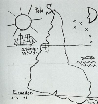
Fig. 4. Inverted America (América Invertida). Museo Juan Manuel Blanes, Montevideo.
The force of Torres García’s inversion comes precisely from the fact that the old map remains present. We know that Mercator’s South America has been turned “upside down”, only because another orientation has become so deeply sedimented that North feels naturally like up.
América Invertida makes orientation itself visible as convention – and convention as conviction. The old cognitive map remains recognisable inside the act of turning it around. And in turning it around, contestation begins.
This is why the “Correct the Map” resolution matters. There is something hopeful in an African-led initiative bringing 164 states together to do, through international law and multilateralism, something akin to Torres García’s gesture: to expose an inherited orientation and begin turning it around, knowing that the old map – and much of the world it helped to organise – will remain for a long time to come.
At a moment when so much ink is spent on the crisis of international law, this reminds us that international law can still be a site where deeply asymmetrical ways of organising the world are brought into view and contested. There is some critical hope in that. More often than not, justice begins by challenging settled cognitive maps. And turning maps around, whenever the chance appears.
To include a map in a post about global justice in which Crimea is depicted as Russian certainly is a choice.